Blacks Beach

Blacks Beach
Sunrise

Sunday, October 30, 2011

Walpole

We are now enjoying a few days in Walpole. Walpole is surrounded by the Walpole - Nornalup National park so there are a lot of big trees around. The weather hasn't been the best as it rained for the first 3 days we were here. But on Saturday the weather cleared. There is still a cool breeze blowing but this is expected as it is the south west of WA. We do have a fireplace so we are going to do some cooking on it (I mean Ray is going to do some cooking on it). The caravan park has been pretty busy over the weekend as it was a public holiday in WA on Friday. They didn't have their public holiday in early October like all of the other states. They decided to give it to WA on Friday as the CHOGM conference was on.

On Saturday we went for a drive,but first we went to Walpole markets and I bought some Chrissie presents. We then drove out to Swarbrick forest. This is a significant site because it was one of the focal points for people who campaigned to preserve the old growth forests for future generations. Their efforts culminated in the desire to create the Walpole Wilderness. Swarbrick is an artistic interpretation of these efforts. One of the most spectacular interpretations is the Wall of Perceptions.

Entrance to Swarbrick Forest

Identical twins reflected in Wall of Perception

Forest reflected in the Wall of Perception

On of the sculptures, suspended from the trees

Ray and his twin
Next we drove down to Fernhook Falls.

Water cascading over the weir at Fernhook Falls

The rapids at Fernhook Falls

Old Fordson Tractor on road to Fernhook Falls
On Sunday we went for a drive out to Conspicuous Cliffs and then up to a forest lookout, then to the Giant Tingle Tree and lastly to Circular pools.

Conspicuous Cliffs Beach looking north

Conspicuous Cliffs Beach

Nornalup Inlet and Frankland River from lookout
Looking up at an old Tingle tree
Maura in the base of the Giant Tingle Tree
Giant Tingle
Ray in the Giant Tingle
Circular pool looking upstream
Circular Pool

This is a legless lizard, not a snake. But it sure looked like a snake


We are moving on to Denmark tomorrow as we want to be somewhere where we can go out for Melbourne Cup. It is on at a nice civilised time of 12md here because of the three hour time difference.

Tuesday, October 25, 2011

Pemberton

We moved from Busselton to Pemberton last Wednesday. Pemberton is 335km south of Perth in the south west corner of WA. It is surrounded by Karri, Marri and Jarrah forests and has a huge sawmill in town. There are lots of art and craft shops, wineries, lots of farming, marron farms and trout farms as well as beautiful tourist drives.
Pemberton was mostly settled in the 1920's when "free" land was offered to British ex servicemen who had returned from the First World War to face unemployment. They were called groupies and in return for their free land were expected to set up dairy farms. Life was very tough as the land had to be cleared of the huge trees and the settlers also had to survive the depression. A lot of them succeeded and the area is now quite prosperous.

We have set up at Pemberton Caravan Park, surrounded by forest and visited daily by ducks, 28's (a type of mallee ringneck parrot), magpies and blue fairy wrens.


This is a 28 parrot

Ray called this photo "2 Birds eating pretzels"

As I am writing this Blog I can hear the black cockatoos screeching in the tree tops.

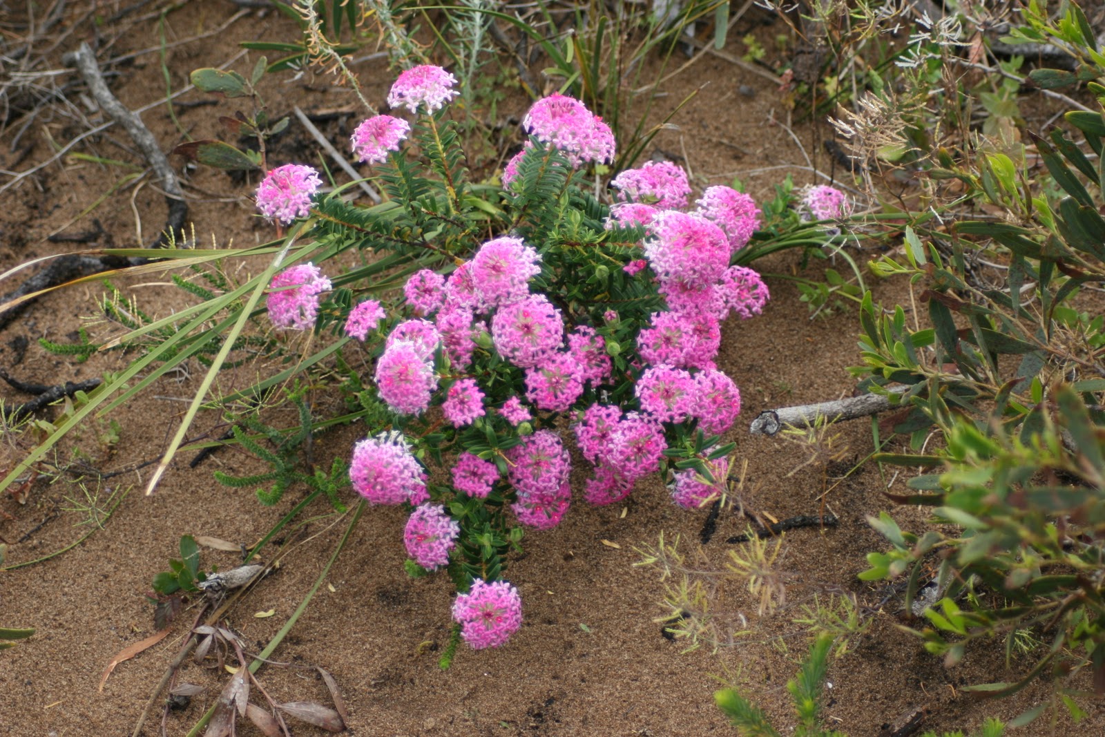
The first drive we did was on Thursday and we headed out to Point D'Entrecasteaux which is about 50km south of Pemberton. There were some lovely lookouts to the Southern Ocean and we saw some whales frolicking. We went to a little fishing village called Windy Harbour and were lucky that it didn't live up to its name.
View out to the Southern Ocean from Point D'Entrecasteaux

Ray and Maura with Tookilup behind them

Looking north along Salmon Beach

Curly leaf Banksia
Cathedral Rock, Windy Harbour
Grass tree in flower

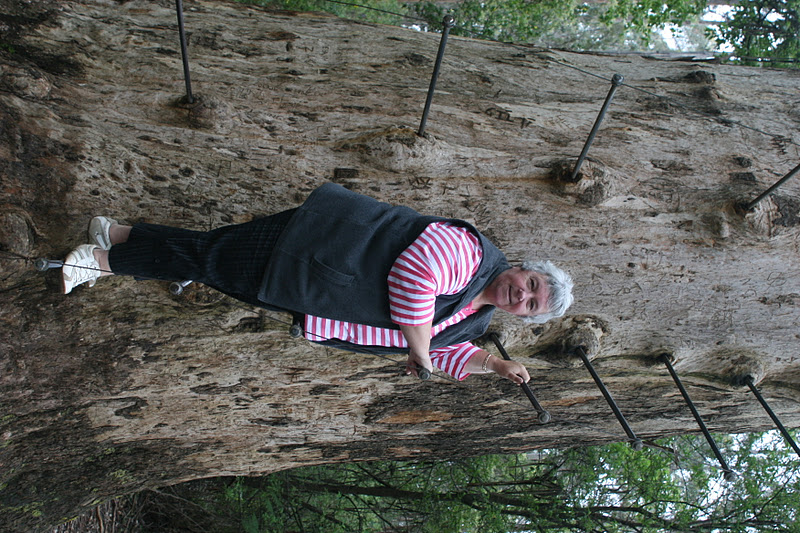
The next day we drove out to the Bicentennial Tree. In the 1930's and 40's fire lookouts were constructed in giant Karri trees. Now people can climb these trees and have a look at the view from about 60 to 75 metres up. The problem is that you have to climb up steps made from steel spikes which circle around the tree like a stairway. Only the brave do this. We preferred to look although our friend Terry climbed the Gloucester Tree.

The Bicentennial Tree. You can see the steel spikes which are the steps to climb the tree

In the bottom third of the photot you can see the lady climbing the tree. She had reached the first platform and was on her way up to the top platform.
The Bicentennial Tree is 75 metres high and we did see a lady start to climb up it.

Next stop was a chocolate distillery and I tasted some but ended up buying some coffee liquor as the chocolate was a bit rich even for me. We then went to The Lavender and Berry farm for lunch which was a delight for both taste buds and sense of smell.

Next  day we decided to go on a longer trip - The Karri Forest Explorer. This is a self drive tour through the beautiful Karri forests for about 86km around Pemberton.We went through the Big Brook Forest, The Beedelup National Park and the Warren National Park. We saw waterfalls, huge trees, wildflowers and magnificent scenery.
Big Brook Dam

Looking down the forest trail from the top of the road. These are mainly Karri trees.

Beedelup Falls

Canoeists paddling on the Warren River

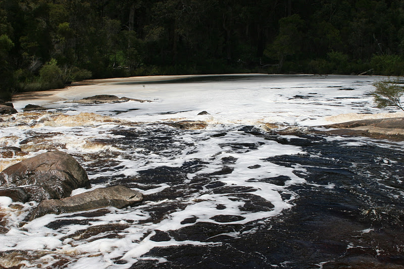
On Sunday we went on the Donnelly River Cruise. We didn't know what it would be like as it had rained all night but when we woke up in the morning it was a little clearer so off we went. Terry and Sue went with us as we had caught up again at Pemberton. The bus picked us up at the caravan park and drove us to the river where we got on the boat for a leisurely cruise down the river to its entrnce, had morning tea and a walk on the beach and then cruised back to our start point.
It was a great morning. There is no road access to this area so the river is pristine. There are some shacks??? on the river down near the entrance and the only way they can be reached is by boat. The southern ocean near the entrance to the river was wild as it was quite windy.

This is the boat we cruised the Donnelly River on. Just as well it was enclosed as it was quite cool.

The banks of the Donnelly River

Fishing shacks on the banks of the river.

Looking out to the Southern Ocean from the sand hills near the entrance of the Donnelly River

Reflections of the Melaleuca Trees in the river

Then back to camp and Ray cooked a piece of beef in the Cobb cooker, and Sue did lovely baked vegies and we all had dinner together. It was quite delicious.
We are having a quiet Monday as the weather is a bit funny and we will see what it is like tomorrow as we still have a couple of things to look at before we leave for Walpole on Wednesday.

Well it is now Tuesday and we decided to go for a run out to the Gloucester Tree. It is only about 3km from Pemberton and is another of those fire look out trees. It was in a lovely area with wildflowers around. A man and his 2 children had actually climbed to the platform at the top which is about 61 metres off the ground.

Looking up the Gloucester Tree from ground level

Maura pretending to climb The Gloucester Tree

Ray on The Gloucester Tree
The weather is not so good today. Threatening rain and thunderstorms, so we took down the awning ready for our departure tomorrow as it is better to pack it up when it is dry.
That is enough blogging for now. I will Blog again from Walpole.

Wednesday, October 19, 2011

Bussleton

We moved from Mandurah to Bussleton on Wednesday 12th October. It wasn't far, only about 160km. You can't drive too far in one go you know. We had a quiet couple of days before heading out and about. The weather wasn't very nice so we caught up with some domestic stuff and did some shopping. Friday 14th wasn't a brilliant day but we decided we had better have a look around because if we waited for fine weather we might still be in Busselton at Xmas.

Looking towards Moses Rock which is off Caves Road in the Margaret River region
 We headed towards Margaret River via Cowaramup and then out to Moses Rock. Because the day was windy, the sea was pretty angry with the waves crashing on to the beach and rocks.
The waves were so blue as they were curling over that it was worth a picture.
You could even see bits of weed in the break.

Next we visited the goody shops, Margaret River Nougat Shop and the Margaret River Chocolate Factory. Margaret River Chocolate is lovely, very creamy and smooth. I would bring you all some home, but it won't last that long. Sorry.
Then to Prevelly, which is where the Margaret River enters the sea sometimes. (Other times it is silted up and only gets out on a big tide). We both thought the entrance would be something spectacular but it wasn't.
Then next stop the Fudge Factory, the Berry Farm, for some jam and lastly the Cheese Factory. This was just about enough for one day, so we trundled back to Busselton for Happy Hour.
Saturday was another quiet morning and Sue and Terry appeared and we had a long Happy 3 hours in the afternoon. I am glad we don't do that too often.

 So on Monday we decided to go to Gnomesville. We had never heard of it until Terry and Sue told us about it.
Apparently some time ago some people were moving from a house to a unit and decided to put their garden gnomes on a roundabout out east of Bunbury. Of course the council didn't like this so they cleared an area beside the roundabout and moved the gnomes there. Over the years people stop by and place gnomes all around.
A lot of social clubs have put groups of gnomes there. Hens parties have got groups of gnomes. Bikie clubs, car clubs, rotary clubs, retirement villages. There are thousands of gnomes.
They are spread over quite a large area. Some are under logs, beside creeks, in trees.
 As you can see some even have their own caravans.

Maura with purple gnomes

Ray with gnomes


These are the gnomes we left. We put them near Santa as we thought they would be busy soon and that would keep them out of mischef


Gnomesville, a magical place. Now I know where all of those stolen gnomes have gone.

On Tuesday 18th October we went for a run out to Cape Naturaliste which is to the west of Dunsborough and Bunker Bay. It had rained on and off all morning so we left Busselton about 8am and drove straight out to the Cape. We wanted to walk down to the whale watching platform and didn't want to get caught in a shower. It was about a 1.2km walk down to the platform and the last 200metres was quite steep but it was worth it. The view was pretty good. The sea lions were sleeping on rocks below and you could see whales further out to sea. We did get caught in a light shower on our way back to the car.


Looking out from Cape Naturaliste


Seals basking on the rocks below Cape Naturaliste

From there we drove to Sugarloaf Rocks and then to Canal Rocks.


Sugarloaf Rock

Canal Rocks

More wildflowers. Rose Bantjine

The Busselton Jetty is 1.8km long and has recently been rebuilt after falling into disrepair. There is an Underwater Observatory at the end and a train goes out along it also.